User Maps
The User Maps feature is used to save maps and GeoWorkspaces within a configuration. You can save maps you create and use them in a later GeoMedia SDI Portal session.
To save a map or GeoWorkspace, click User Maps on the Tools tab ![]() .
.
In the User Map window, you can add and manage single maps and GeoWorkspaces (a collection of maps).
You can add maps and GeoWorkspaces as follows.
- Add from the map window:
To add a map or GeoWorkspace from a map window, from the User maps box, Maps/GeoWorkspaces menu, select Add > From map. This method lets you save the state of all displayed layers and the extents for currently visible maps.
- Add from an exported file:
To add from an exported file, from the Maps/GeoWorkspaces menu, select Add > From gpm/gpw file. A map file has the .gpm extension, and a GeoWorkspace has the .gpw extension.
Each Map and GeoWorkspace has a menu with the following functions and commands:
- Display – Displays maps
- Public – Activates the Link function
- Link – Gives you a direct link to a map that can be forwarded to another user
- Rename – Changes the name of a map or GeoWorkspace
- Remove – Removes a map or GeoWorkspace
- Properties – Sets such properties as Map ranges, Predefined scales, Scale bands, and Scale ranges
- Map ranges – Map ranges (bounding box) for common coordinate systems are used by the Fit all function. When you display the map and click Fit all, the map area is adjusted to the extent specified in the fields [X min], [Y min], [X max], and [Y max].
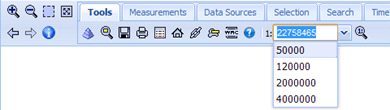
- Predefined scales lets you add predefined scales for saved maps. When you display a map with predefined scales, a predefined list appears in the field for changing the scale. You can also give any value of the denominator of the scale in the box.
To add predefined scales, select Properties for the map. On Predefined scales tab, click Add and type a scale denominator. Click Save. Next, you display the map. A drop-down list with predefined scale options is provided.
- Scale bands lets you specify the scale in which different layers of the map will be displayed. To add a scale band, click Add and provide a name for the scale band and scale denominator. You can decide which layers should be displayed in which scale bands. To do this, run the tool for scale band setting in the Tools toolbar. (See Scale Bands Settings for more information.)
- Scale range lets you specify a range of scales in which the entire displayed map is available, regardless of scale band settings for single layers. Data can only be shown on scales containing values between the minimum and maximum scale that you specify.
| Top of Page |