Performing Measurements on the Map
GeoMedia SDI Portal provides a range of tools for performing measurements on the map. Tools for measuring distance, area, and points (coordinates) are grouped on the toolbar in the Measurements tab, which includes the following elements:
- Measure point
- Measure distance
- Measure area
- Clear measures
![]()
Icon |
Name |
Description |
|
Measure point |
Lets you read the geographical coordinates of a designated point. Coordinates of a point are displayed on the map. |
|
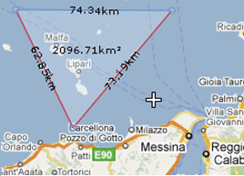
Measure distance |
Lets you measure the distance between two points or multiple points. |
|
Measure area |
Lets you measure the polygon area. Distance between points is also measured. |
| Top of Page |